1700-1735 French Establish Three Outposts
The French established three outposts along the river trade route on the Wabash-Maumee: one at the present-day of Fort Wayne, one near present-day Lafayette (1717),
1750 French Occupation
By 1750, the French had built 60 forts from the St. Lawrence River to the mouth of the Mississippi. Present-day Indiana was part of New
1754-1763 French and Indian War
The French and Indian War (7-Years-War) was part of the larger struggle between the French and the English. At the end of the war, French forts were occupied by the British. The land that was Indiana was among the lands ceded to Britain by France.
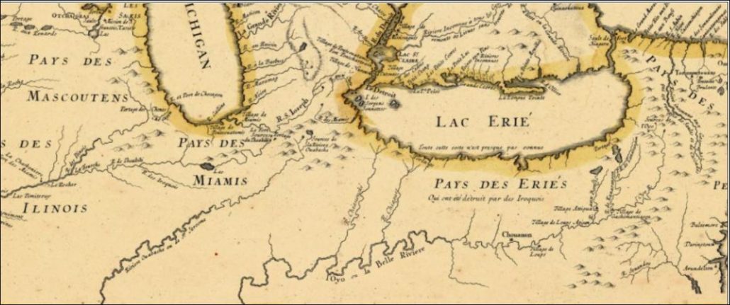
1755 Indiana as Part of New France
Notice “Pays des Miamis” in northern Indiana. That translates to “Miami County”. The French built forts along the waterways from Canada down to New Orleans.
1763 Restriction on Westward Movement
The British took possession of the area that included what would become the Northwest Territory from the French. In the Royal Proclamation of 1763, Britain forbid American colonists from settling in the “New West”, which included present-day Indiana. The British allowed a few hundred Frenchmen who were already settled in the area to remain but the colonists were restricted from crossing the Appalachian Mountains to settle. The British had set aside this land in treaties with Native Americans.
As crowding and competition increased, the prohibition put stress on the European settlers and contributed to the American rebellion and revolution. The line was just west of Appalachia and is referred to as the Proclamation Line.
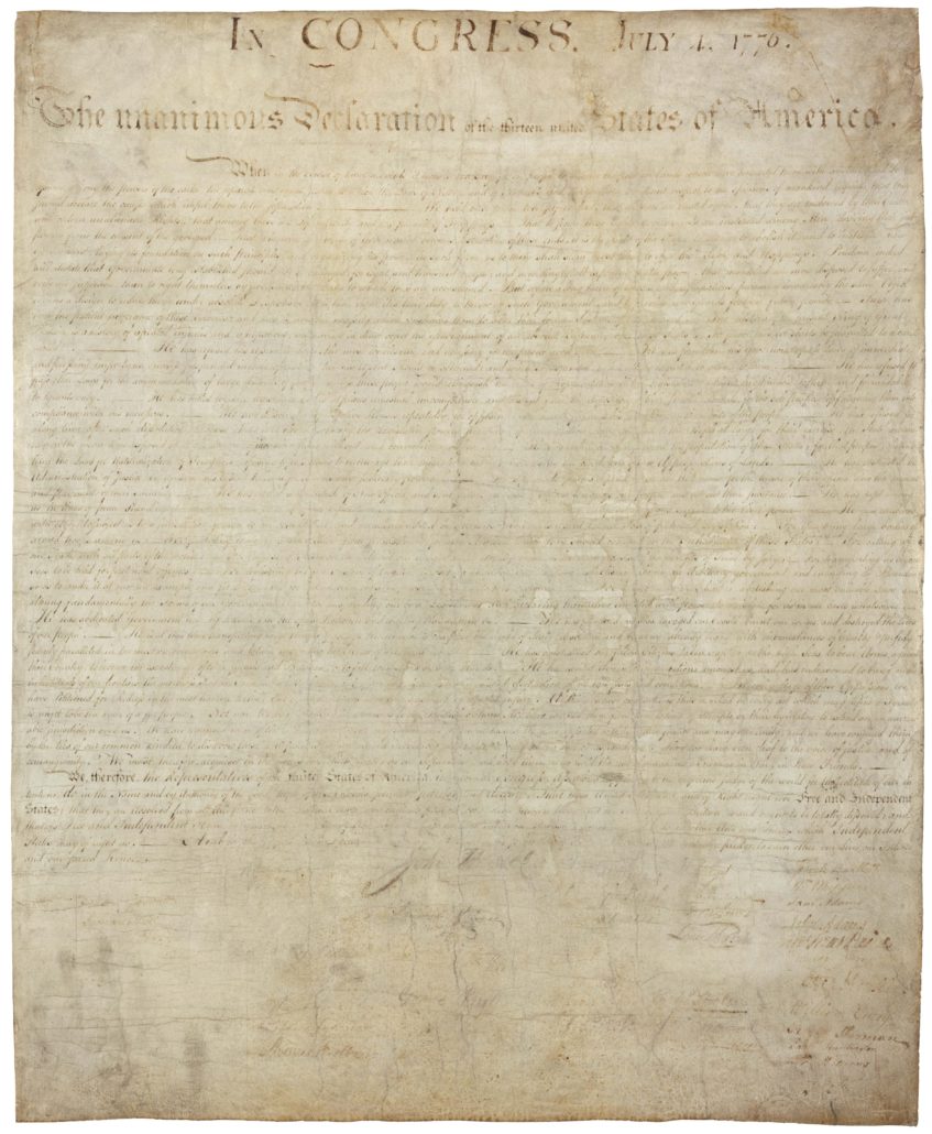
1776 July 4
Declaration of Independence
The British Colonies in North American (present-day United States) declared their freedom from British rule. The Declaration of Independence expresses the ideals on which the United States was founded and the reasons for separation from Great Britain.
Transcript of the Declaration of Independence
1778 The Northwest Territory is Won for the Patriots
George Rogers Clark marched a militia of mostly sympathetic Canadian volunteers through present day Ohio and Indiana to Illinois in 1778. Clark won what became the Northwest Territory for the patriots with the Siege of Fort Vincennes (also known as the Siege of Fort Sackville or the Battle of Vincennes) to help end the U.S. Revolutionary War.
1778 Treaty with Delaware; Treaty of Ft. Pitt
Smithsonian Magazine has a complete article on this treaty and how it balanced the power with the newly formed United States.
From the Smithsonian Blog, Smithsonian Voices, Museum of the American Indian; 2018 May 21: A Brief Balance of Power—The 1778 Treaty with the Delaware Nation:
“On September 17, 1778, the newly formed United States Continental Congress dispatched a treaty commission to the confluence of the Monongahela and Allegheny rivers to negotiate America’s first treaty of peace with an American Indian tribe.
Three leaders—named in the treaty as “Capt. White Eyes, Capt. John Kill Buck, Junior, and Capt. Pipe, Deputies and Chief Men of the Delaware Nation”—represented the Lenape (Delaware) people.
During colonial times, Lenape communities had been compelled to move west from their historic home along the Delaware and lower Hudson River watersheds to lands between modern-day Pittsburgh and Detroit. General Andrew Thomas and his brother Lewis served as commissioners on behalf of the United States. Eleven other Americans witnessed what would become known as the Treaty of Fort Pitt.” ~ Dennis Zotigh
The Delaware Indians came to Indiana and settled along the White River as early as 1795.
National Museum of the American Indian
Smithsonian Voices Blog
Full Article: A Brief Balance of Power—The 1778 Treaty with the Delaware Nation
1783 First Authorized Settlement by White Americans in Indiana
Although there were some European settlers already in Indiana, Clarksville became the first authorized American settlement in present-day Indiana in 1784. The settlement sat on the north bank of the Ohio River, opposite Louisville, Kentucky) at the Falls of the Ohio.
George Rogers Clark used the area during the American Revolution. In 1778 , he built a post on an island at the head of the Falls of the Ohio. The Clark commanded regiment was trained at the post tasked with protecting the west.
After the Revolutionary War, Clark was granted a tract of 150,000 acres for his services. In 1783, 1,000 acres were set aside for the development of a town, Clarksville. The same year a stockade was built and settlement began.
1783 Treaty Ending the Revolutionary War
The Treaty of Paris was signed with the British ending the Revolutionary War.
The Spanish, along with American citizens, marched into Western Quebec (what later became the Northwest Territory, which included Indiana), and expelled the British forces. Sir Henry Clinton lead forces that forced British General Cornwallis to retreat to Yorktown, Virginia. Cornwallis surrendered in October 1781.
On September 3, 1783, the treaty was signed between Great Britain and the United States which officially ended the war.
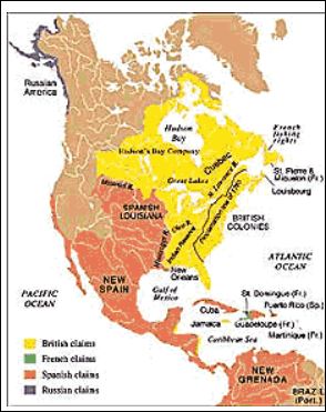
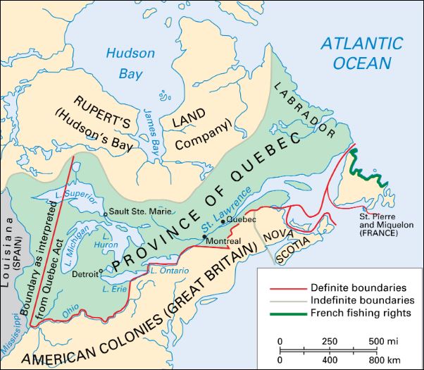
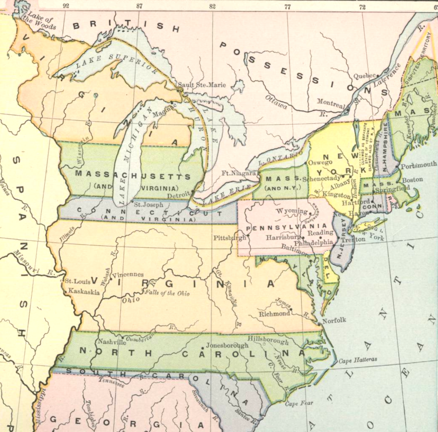
Below: In 1774, Indiana was part of the Province of Quebec. In 1883, present-day Indiana was ceded by the British to the United States.
1785-1795 Little Turtle’s War
Little Turtle’s War, also known as the Northwest Indian War, was fought between 1785-1795. Britain ceded the land in the Northwest Territory to the United States after the end of the Revolutionary War but Britain maintained military forts and outposts around the Great Lakes even after that time. The agreement between the U.S. and Britain, the Treaty of Paris (1783), marked the Great Lakes as a boundary between the two countries.
Britain continued to support Native American agitators. Native Americans had a centuries-old history of conflict among themselves over the land surrounding the Great Lakes. In 1785, Native Americans formed the Western Confederation of tribes with the help of Britain to resist European settlers encroaching on the tribal lands. The tribes also wanted all land north of the Ohio River This is considered to be the first conflict of the United States Indian Wars.
The United States was defeated badly in Harmar Campaign in 1790 and St. Clair’s Defeat in 1791. The St. Clair’s Defeat cost the lives of 1,000. President Washington sent General “Mad Dog” Anthony Wayne to lead the forces to enforce land rights in the Northwest Territory. (Note: Ft. Wayne, Indiana is named for Anthony Wayne.)
Unknown to the Western Confederacy who thought that Britain would help them, the Brits had signed the Jay Treaty in 1795 which gave assurances to the U.S. that Britain would no longer aid the Native Americans.
In 1794, General Wayne won a decisive victory in the Battle of Fallen Timbers on August 20, 1794.
After the defeat of the Western Confederacy, the Native Americans were compelled to sign the Treaty of Greenville in 1795. The treaty, included the Delaware, Wyandot, Shawnee, Ottawa, Chippewa, Potawatomi, Miami, Wea, Kickapoo, and Kaskaskia tribes. The treaty redefined the boundary between the U.S. and Native American land. This line was known as the Greenville Treaty Line. The treaty gave a large swath of land to the United States government that included northwestern Ohio and a strip of land in southern Indiana.
(Map from Ohio Lands and Their Subdivisions (1918) page 98)
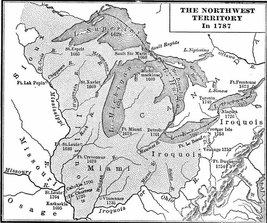
1787 Northwest Territory Established
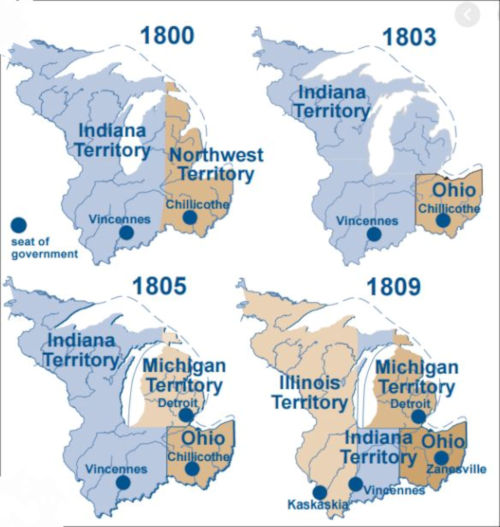
The Northwest Territory was established by the Northwest Ordinance on lands that that later became Indiana, Ohio, Illinois, Michigan, Wisconsin and part of Minnesota. The territory marked the the nation’s first post-colonial organized territory. The territory ceased to exist on March 1, 1803 when other territories were made from the land it contained.
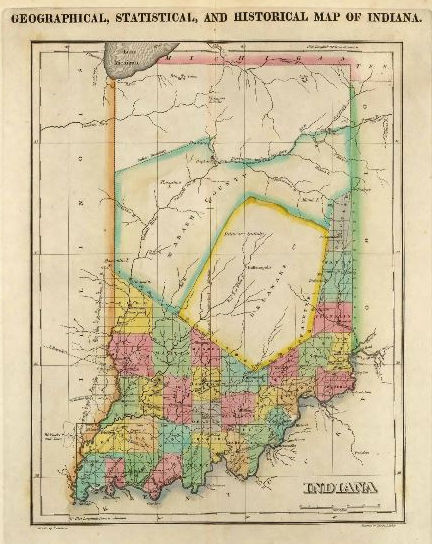
At first, the land in the Territory was absorbed first into Indiana Territory and Ohio. Indiana territory was much larger than the state of Indiana today. Indiana Territory existed from July 4, 1800, to December 11, 1816, ending when Indiana became a state.
Book: Charles Kendall Adams, A History of the United States (Boston, MA: Allyn and Bacon, 1909) pg 189; Map Credit: Courtesy the private collection of Roy Winkelman
Map Courtesy of: Indiana History Blog, (blog.history.in.gov)
1788 Administration of the Northwest Territory Begins
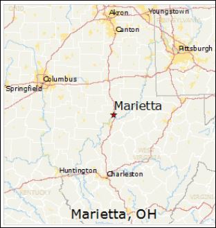
Governor Arthur St. Clair arrived within the Northwest Territory at Marietta, Ohio to begin administration of civil duties within the territory. St. Clair formally established the territorial government on July 15, 1788. The settlement of Losantiville was renamed by St. Clair to “Cincinnati” in 1790 and he moved the administrative and military center of the territory to Fort Washington.
Fort Washington was in downtown Cincinnati, providing easy access to the Ohio River. The Fort was the major staging area for settlers, troops and supplies during the settlement of the Northwest Territory.
The first written criminal and civil laws of the Northwest Territory were established. Thirty-seven different laws were written with the understanding that the laws had to have been passed previously in one of the thirteen original states. A structured court system was established.
Many early trips west began in Marietta or Cincinnati. The first part of Indiana to be settled was in the south and southwest, along the rivers.
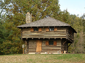
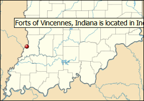
The settlement of Indiana happened primarily from the rivers. The south and southwestern parts of Indiana were divided into counties first. Fort Vincennes was established by the French between 1731-1732. The Fort was later was occupied by the British who called it Sackville before it became a possession of the U.S.
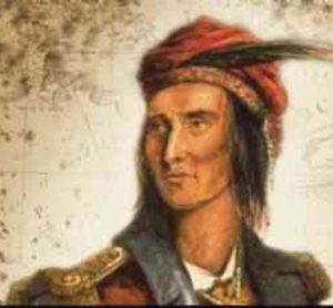
Vincennes was used to muster soldiers to fight in the Battle of Tippecanoe in 1811. The soldiers marched along the Wabash to near the confluence of the Tippecanoe and Wabash Rivers. The area is known today as Battle Ground, Indiana. It was there that General William Henry Harrison met the confederacy of tribes led by Tenskwatawa, “The Prophet” for battle. Tenskwatawa was the brother of the great Shawnee warrior, Tecumseh, who was not at the battle.
Vincennes was the first capital of Indiana Territory until it was moved to Corydon on May 1, 1813.
1789-1797 George Washington served as the 1st US president
George Washington (February 22, 1732– December 14, 1799) served as the first president of the United States from 1789 to 1797. As a General Washington, he led Patriot forces to victory in the Revolutionary War. In 1787, he presided at the Constitutional Convention which established the U.S. Constitution and a federal government.
1791 Defeat of St. Clair
Tribal warriors led by Mihšihkinaahkwa (Little Turtle) of the Miami and Weyapiersenwah (Blue Jacket) of the Shawnee led the defeat of the American Army at St. Clair’s. The American army lost approximately 1,000 men, the largest defeat between tribal forces and the American Army.
Between 1774 and 1794, Indian villages in New York, Pennsylvania, Indiana, and Ohio were constantly attacked by the American army and militias. The native Americans saw 100 villages burned and untold violence and casualties.
1794 Battle of Fallen Timbers
The Battle of Fallen Timbers effectively ended the Northwest Indian War led by General “Mad Anthony” Wayne. Ft. Wayne and Wayne County are named for him.
The Battle of Fallen Timbers (20 August 1794) was the final battle of the Northwest Indian War, a struggle between Western Confederacy of Native American tribes with the British, fighting against the newly formed United States. This was the battle for control of the Northwest Territory, of which present-day Indiana was a part.
1795 The Treaty of Greenville
The Treaty of Greenville was negotiated to end the violence and establish lands for the tribes. The Miami tribes were given the lands in the Wabash River watershed with the exception of the White River which was to be occupied by the Delawares. This was but a temporary measure for as the white Americans pushed west the agreement was nullified.
1795-1799 Delaware Indians Settled at White River
Delaware Indians settled around present-day Yorktown. After 1800 there is no record of fighting with native Americans in our area. When Oliver H. Smith platted Yorktown, he named the town for the “York Indians”. The native Americans who settled along the White River, were part of the Lenape/Delaware Tribe coming originally from the area that became New York stopping in Ohio on their journey.
1797-1801 John Adams 2nd US president.
1797-1801 John Adams served as the 2nd US president. In his re-election campaign of 1800, Adams lost to Thomas Jefferson, becoming the nation’s first one-term president.
Adams signed the unpopular Alien and Sedition Acts of 1798 which restricted the activities of foreign residents in the United States and limited free speech. Today, their passage is widely recognized as one of the biggest mistakes of Adams’ presidency.
At least 26 individuals were arrested and tried under the Sedition Act. The primary targets were Republican newspaper editors opposed to Adams and the Federalist party ideals. The meaning of a free press and the right of opposition parties to speak were widely debated.
Trivia: Adams was the first president to live in the White House.
Read more about the Alien and Sedition Acts of 1798. Two dueling parties fighting against each other amid challenges of the new county and impending war with France is a deja vu moment in history. ~Julie
1800 Indiana Territory is Formed
Congress separated Ohio from the Northwest Territory in 1800. The remainder of the Northwest Territory then became Indiana Territory.
George Roger Clark’s Grant in Present-Day Indiana (Clark County)
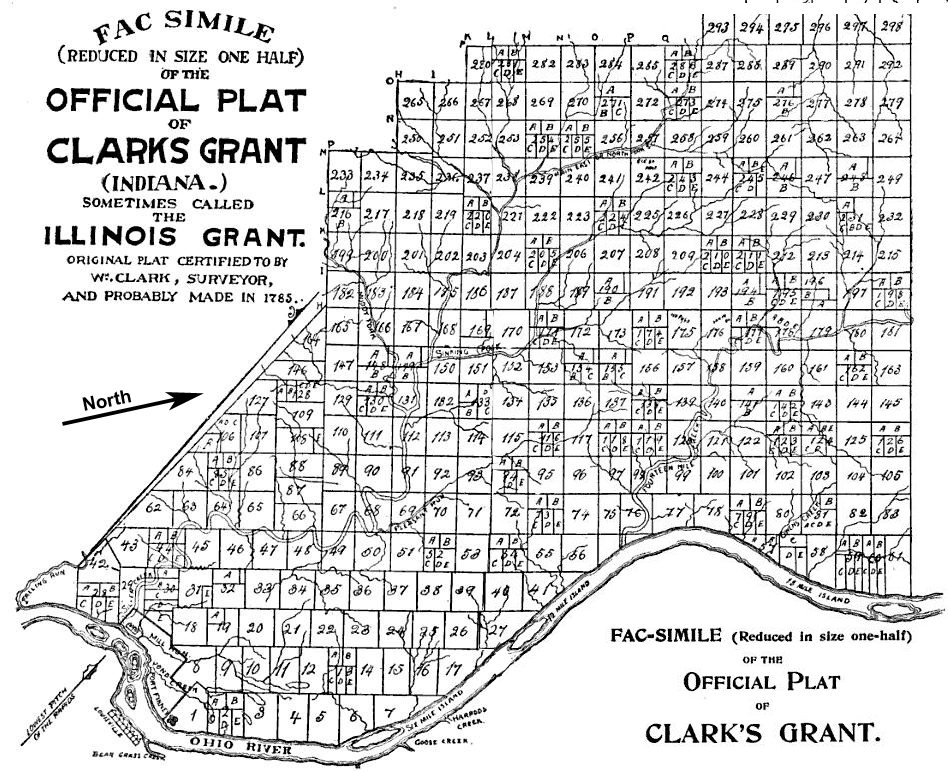
Map: William Hayden – English, William Hayden (©1896). Conquest of the Country Northwest of the River Ohio, 1778–1783, and Life of Gen. George Rogers Clark. Indianapolis: Bowen-Merrill., pages 852, 853 Public Domain.
Land granted by the state of Virginia on January 2, 1781 to George Rogers Clark and the soldiers who fought with him during the American Revolutionary War, became the first authorized settlement in the present-day Indiana. Clark’s Grant contained over 150,000 acres and was located in present-day Clark County, Indiana and parts of the surrounding counties.
Clark’s Grant sat across the river from Louisville, Kentucky on the northwest side of the Ohio River. Clark was certainly familiar with this area before the grant. During the Revolutionary War, he built a post on an island in the Ohio River to train Revolutionary War soldiers from the Virginia militia. He led them in capturing a large part of the Illinois Country as part of the Illinois Campaign. The captured land, which included most of present-day Indiana became Illinois County, Virginia.
There was little cash to pay men to fight the Revolutionary War. Land was offered as an incentive to get recruits to sign up as soldiers. After the war ended, Virginia granted the soldiers and officers land to compensate them for their service in their militia as did other states and the federal government.
1800 Indiana Territory is Formed
Congress separated Ohio from the Northwest Territory in 1800. The remainder of the Northwest Territory then became Indiana Territory.
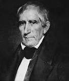
1801 Harrison Governor of Indiana Territory
1801 William Henry Harrison became governor of the Indiana Territory and served 12 years in that position. His desire was to empty the lands of
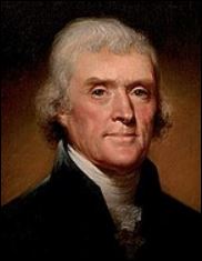
1801-1809 Thomas Jefferson 3rd US president
1801-1809 Thomas Jefferson served as the 3rd US president
1804 Christian Indians Burned at the Stake
Tate-e-bock-o-shee and his nephew, Billy Patterson, were burned at the stake for “witchcraft” at the Indian village near Yorktown. Some traditional Native American tribe members
1804 Indian Torture Stake Delaware County
Full Article: The Indiana Quarterly Magazine of History Vol. 1, No. 4 (Fourth Quarter, 1905), pp. 176-179 (4 pages)
1804 Treaty with the Delaware
The Delaware Treaty of 1804 stipulated that the Delaware Indians held the right to all country between the Ohio River and the White River. The
1805 Tecumseh and the Prophet at Munsee Town
Tecumseh and his brother, Tenskwatawa “The Prophet”, lived in one of the Delaware Indian villages at Munsee Town during this year.
1809 Treaty of Fort Wayne
The Treaty of Ft. Wayne resulted in over 3 million acres being acquired for the settlement of white pioneers and settlers in Indiana and Illinois.
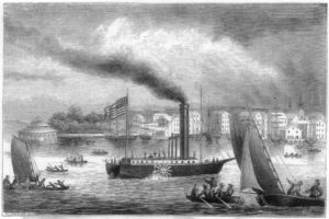
1811 Steamboats Arrive on Ohio River
1811 marked the arrival of steamboats in Indiana territory along the Ohio River, “The beginning of steam-boating on the Western rivers dates to 1811 when
1820 Polly v. Lassalle Opinion on Slavery
The Indiana State Supreme Court ruled in 1820 that slavery was expressly prohibited in Indiana by its constitution in 1816. This ruling applied to Polly
1830 Indian Removal Act
The Indian Removal Act of 1830 authorized the American government to enforce the removal of Native Americans from the eastern United States to lands west of the
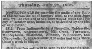
1837 Proposal of Mail Route to Yorktown
NEW MAIL SERVICE The state of Indiana considers a proposal for a three day-a-week mail service from Indianapolis to Greenville, Ohio via Munceytown and Yorktown
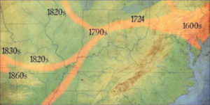
200 Years Ago–Native Americans on the Move
Two-hundred-years ago, Delaware County began recording the first permanent white settlements on public land. In 1818, the Treaty of St. Mary’s was signed as six
200-Years Ago: Native Americans on the Move
By Julie Musick Hillgrove (Copyright 2021. Used with permission of the Author) A slightly different version can be found in the YHA Newsletter March/April 2021.

Western Improvement Stock
Purchased by William H. Dike–5 shares–20 Feb 1894 From an eBay image

History of the District Schools in Mt. Pleasant Township
By Julie Musick Hillgrove Indiana Territory was very sparsely settled when it was first formed. From 1805-1815, early students were taught by an instructor who

1892 West Muncie Resort is Promoted
1892 Western Improvement Company promoted “West Muncie”. Lake View Hotel is completed 26 Nov.

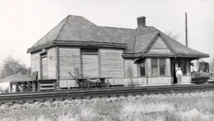
1892 Yorktown Train Depot Burns
1892 Yorktown train depot burned during the winter. It was decided that the new depot would be in West Muncie amid many protests.
1892 New Corner Becomes Gaston
1892 New Corner petitioned to change its name to “Gaston” to help market gas wells in their village. The name was adapted “some time later”.
1892 Delaware County Courthouse Fire
1892 Delaware County courthouse is damaged by fire. Early government and civil records are lost.
1893-1897 Grover Cleveland President
1893-1897 Grover Cleveland serves as the 24th president. He is the only U.S. president to serve two non-consecutive terms
1893 Severe Drought in Delaware County
1893 Severe drought damages crops in Delaware County (Aug)
1893 Lake View Hotel Opens
1893 Lake View Hotel opened by reception and grand ball by the Muncie Lodge of Elks. West Muncie post office established (22 Feb)
1893 National Financial Panic
1893 National economic panic. Anxiety spreads as glass factories close for the summer. Workers unsure if the factories will reopen. West Muncie project loses support of

1893 Muncie Smallpox Epidemic
1893 Muncie has a small pox epidemic on the south side. No electric street cars run to the south side. Quarantine lasts 8 weeks (11 Sep
1894 Lake View Hotel Attached by Sheriff
1894 Lake View Hotel in West Muncie is attached by sheriff for non-payment of taxes (15 Feb)
1895 Epidemic Closes Schools and Churches
1895 Schools, churches close because of the diphtheria epidemic (14 Dec)
1896 Eastern Indiana Normal University is Organized.
1896 Eastern Indiana Normal University is organized. Later, called Ball State Teachers College and Ball State University (23 Jun)

1897-1901 William McKinley President
1897-1901 William McKinley served as the 25th president
1898 The Cammack Sawmill Burns
1898 The Cammack sawmill, the town’s only industry, burns and is not rebuilt.
1898 Yorktown Pike Ceases to be Toll Road
1898 The pole is removed and toll house destroyed on Muncie-Yorktown Pike. After 40 years, Yorktown Pike ceases to be a toll road. The county commissioners
1898 The Morning News begins using Linotype machines
1898 The Morning News (Muncie) begins using Linotype machines, the first in the Delaware County (25 May) The Linotype machine, was developed in the United States
1899 Franchise for Electric Rail Through Yorktown
1899 A franchise is granted by county commissioners to George F. McCulloch for the electric rail road from Muncie west along highway through West Muncie, Yorktown and Daleville to the

1899 Yorktown Methodist Church Dedicated
1899 Dedication of Yorktown M. E. Church (25 Jun). The church received its first deed in 1875 on land that was set aside by Oliver H.
1899 Decision Against Muncie Pulp Co. for Polluting
1899 Appellate court affirms decision against the Muncie Pulp Co. for polluting the water of Buck Creek (21 Dec)
1900 Interurban Service Begins in Yorktown
1900 Interurban (electric train line) line between Muncie and Anderson begins with stops in Yorktown. (1 Oct)

1901-1909 Theodore Roosevelt President
1901-1909 Theodore Roosevelt served as the 26th president
1902 Express and Freight Service to Indianapolis
1902 Express and freight service inaugurated by Union Traction line Muncie to Indianapolis.
1904 Buck Creek Bridge Replaced
1904 First large concrete bridge in the county is built over Buck Creek at Yorktown, replacing the iron bridge carried away by the flood in March.
1904 Daleville Mill Burned
1904 Daniels and Overman Flour Mill at Daleville, built by Peter A. Helview burns. (6 Jan)
1904 Delaware County Children’s Home is Built
1904 Delaware County Children’s Home builds a new home for orphans. The new facility can house between 75-100 children who attend Yorktown Schools.
1904 Disastrous Flooding
1904 Disastrous flooding of the White River. Yorktown bridge washed away. Severe damage across the county (26 Mar)
1909-1913 William H. Taft President
1909-1913 William H. Taft served as the 27th president
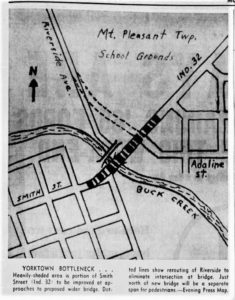
1913 Great Downtown Fire in Yorktown
1913 January 26 Yorktown suffered a terrible fire. The block on the north side of Smith Street was lost and later rebuilt. The fire started in
1913-1921 Woodrow Wilson President
1913-1921 Woodrow Wilson served as the 28th president of the United States
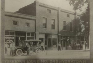
1917 I.O.O.F. Independent Order of Odd Fellows
Posted by James Romack, Facebook, Yorktown Indiana Historical Alliance 1917 I.O.O.F. Lodge 345, The lodge was rebuilt after the block was partially burned after a
1917 War Declared
1917 War is declared marking the beginning of WWI for the U.S. Delaware County had 3,355 men who served. Fifty-five from Delaware County lost their lives
1919 Women’s Right to Vote Ratified
1919 Indiana legislature ratified the amendment giving women the right to vote.
1925 Hance Double Murders
1925 Double murder of Ben and Mary Hance who were brutally stabbed in their home. Charles”One Arm” Wolfe and “Dutch” Anderson were arrested and tried for their murders. (14 Aug)
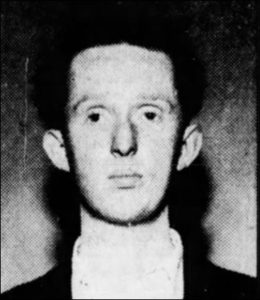
1934 Meat Market Murder
1934 James Marvin Gleason, 21, was arrested for the murder of his father, Lloyd C. Gleason, the owner of the Yorktown meat market. By Barbara Swander Miller March 2021 Newsletter
1950 Methodist Church Fire
In 1950, a major remodeling project was undertaken at the Methodist Church. Christmas services were held in the morning and a wedding was planned for
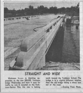
1964 New Bridge Over White River
This is the bridge near the Middle School (left). In 1964 the school contained grades 1-12.
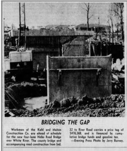
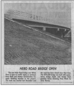
1969 Feb 23 Interview About Nebo Road Bridge
This is a video about the building of the new, concrete bridge over White River on Nebo Road between highway 32 and River Road. Video